Sifelani Tsiko, Fact Check Editor
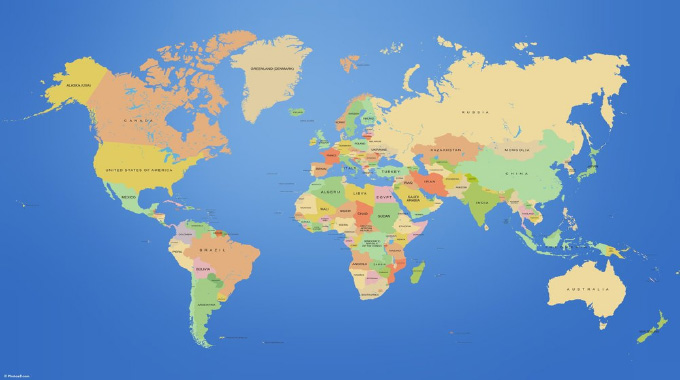
In Africa, there is deepening concern over the reliability and continued use of the ages-long 16th-century Mercator map of the world that shows Africa as being smaller than it is. For example, analysts say, on a typical world map, Canada is shown as a vast nation — with six time zones, endless plains that spread from ocean to ocean — magnifying it as a major continent in the northern half of the globe. But critics now charge that in reality, “three Canadas would comfortably fit inside Africa”. The world map as we know it today is so misleading that this has spurred the African Union to think about the unthinkable.
Africa is now taking a stand and the African Union ratcheting up calls to end the use by governments and international organisations of the 16th-century Mercator map of the world in favour of one that shows the true size of Africa.
In today’s world, there are several myths about Africa that people throughout the world believe to be true. However, this does not paint a true picture of the African continent. These myths are rooted in misinformation, lack of knowledge, and stereotypes. As a danger to the correct projection of Africa, stereotypes lead to the widespread belief of myths.
Background to the distortion
The distortions of the true African continent size are traced down to the European cartographer Geert de Kremer, better known as, and his 16th century map projection — a common template for world maps today — which distorts the size of countries. This Mercator map, though seen as easy to read, distorts proportions, making some land masses larger than they are in reality. These world maps have been used in schools, universities and for various mapping uses since the beginning of the 1900s. It is heavily ingrained in the minds of many people across the world and here in Africa.
This 1569 Mercator map has been used for ages to navigate the seas, helping sailors to navigate the world. It is said that Mercator initially made globes before transferring his map from a three-dimensional curved surface to a flat kind of dimension on a paper. In the process of trying out dimensions and usability, Mercator stretched out the northern and southern extremities of the globe, distorting the true size of the African continent. On the Mercator map, Africa is on the equator, appearing undistorted but looking much smaller than it really is. Canada, Russia, the United States and Europe are greatly enlarged. Analysts say the distortion is largest near the poles. Greenland, which looks about the same size as the whole of Africa on the Mercator, is a classic example while in reality it is no bigger than the Democratic Republic of Congo. While it was applauded as revolutionary by captains and explorers, the projection distorted the relative size of the African continent to the advantage of the West. Nothing has changed since.
The impact
The distortions have lived in the minds of people here in Africa and across the world for more than a century. The impact has been deep. The distortions and stereotypes have created an imaginary world for Africans disconnected from their own. Through colonialism and cartographic tools, the West has sold Africa its civilisation as an ideal to be reached. It has done so by belittling the African geography and cultures through teaching. Africans have been conditioned to accept the Mercator map as true and as one that more accurately displays Africa’s size. This colonialist and condescending spirit is still being perpetuated on various media platforms, government and other multilateral agency documents. Created by cartographer Gerardus Mercator for navigation, analysts say the projection distorts continent sizes, enlarging areas near the poles like North America and Greenland while shrinking Africa and South America. The danger, critics say, is that the Mercator map makes enlarged countries seem unnaturally powerful and intimidating.
“The term ‘power of representation and representation of power’ sums up quite well how maps and the rise of the Western nation-state system — and with that, empire and colonialism — are linked,” Marianne Franklin, professor of Global Media and Politics at Goldsmiths, University of London was quoted in a report in 2017.
“The world maps that prevail today have been embedded in Western imaginations since the British empire. They continue (to prevail) despite many challenges to their fairness and accuracy because they underpin the ongoing Anglo-Euro-American presumption that the world belongs to them, and pivots around these geo-cultural axes.”
Africa takes a stand
Turbo-charged by these disparities and myths, the African Union is now calling for an end to the Mercator myths about the African continent. The tectonic shift in the AU thinking is now underway with various pressure groups lobbying for an end to the use of the Mercator map. The “Correct The Map” campaign led by advocacy groups Africa No Filter and Speak Up Africa has reignited debate with calls for the AU to push for the adoption of the 2018 Equal Earth projection, which reflects the correct sizes of countries.
“The current size of the map of Africa is wrong,” Moky Makura, executive director of Africa No Filter, was quoted saying. “It’s the world’s longest misinformation and disinformation campaign, and it just simply has to stop.” Added AU Commission deputy chairperson Selma Malika Haddadi: “It might seem to be just a map, but in reality, it is not.”
“In reality, Mercator created a false impression that Africa was ‘marginal’ despite this continent of more than one billion people being the world’s second-largest continent by area. Critics say the stereotypes have influenced media, education and policy.”
Way forward
The calls by the AU and those of pressure groups is a step in the right direction for Africa. There is a need to roll out the new maps at various levels in all classrooms here in Africa to correct the stereotypes now and in the future. The fight to correct must not only focus on governments and other multilateral agencies — the World Bank and the United Nations to adopt the Equal Earth map but should also be taken to all digital platforms which continue to foster incorrect perceptions about the size of the African continent. Digital platforms are powerful and campaigns should target these, to win the battle to correct the fallacies about Africa’s size. Africa has to defend its interests. It is up to us, Africans, to take charge of ourselves and debunk the myths. We must invest in the interest of African people — promoting our own true identity and realities.