Online Reporter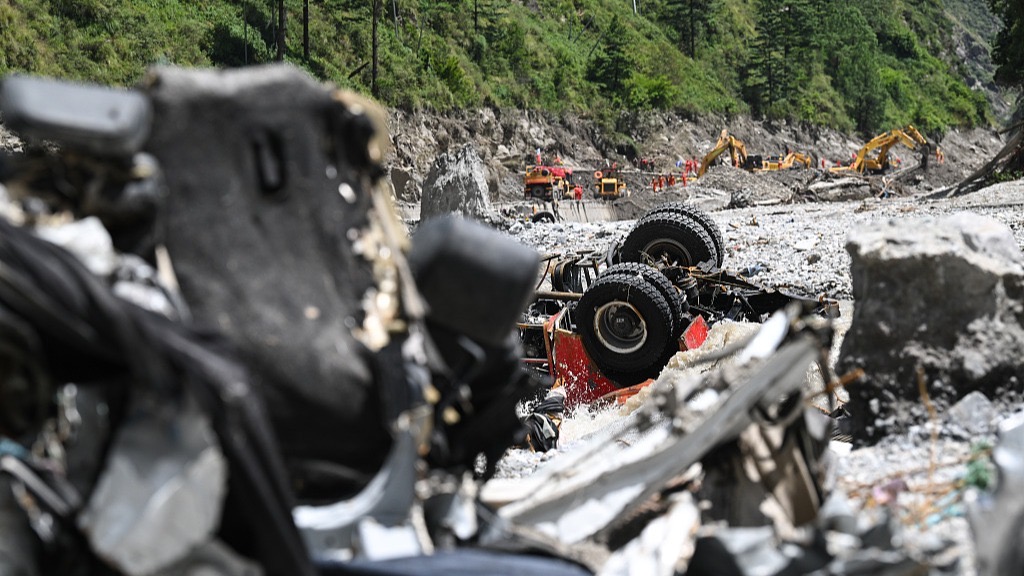
CGTN
Rescue efforts have been ramped up at Gyirong Port in southwest China’s Xizang Autonomous Region after a mudslide in Nepal caused extensive damage to the port area on Wednesday.
As of 1 a.m. on Saturday, seven people had been killed and 554 others remained missing, while two local villagers had been rescued, according to the region’s emergency management department.
Rescuers said Saturday that 2.5 kilometers of the mudslide-hit G216 national highway in Gyirong County has been cleared after days of continuous efforts by multiple engineering rescue teams. Another 1.8 km remains to be cleared to reach Gyirong Port, rescuers said.
Rescue efforts intensify as more teams arrive
At about 4:30 p.m. on Friday, the first team of six members from the Xizang Fire and Rescue Corps and the first group of 15 members with a search dog from the Sichuan Fire and Rescue Corps arrived at the disaster-hit port. They were the first professional rescue teams to reach the core rescue area, the National Fire and Rescue Administration said.
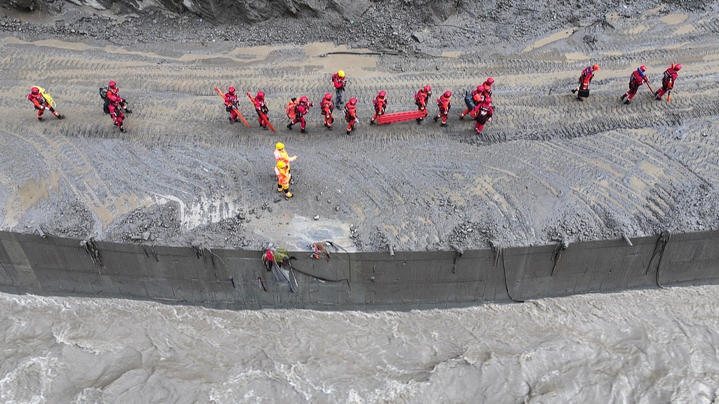
As of 10 a.m. on Friday, a total of 681 fire and rescue personnel and 113 vehicles had arrived in the remote mountainous border area, while 6,612 pieces of rescue equipment and logistical supplies had been dispatched to Gyirong Town, the administration noted.
A total of 2,096 personnel from local military units, the armed police, fire and rescue services, public security authorities, medical teams and other rescue forces have been mobilized for disaster relief.
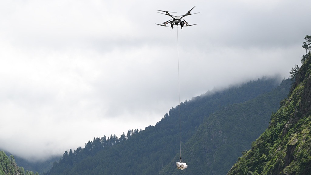
More than 300 vehicles have been deployed for emergency rescue, while drones have been used for search and rescue, crowd management and disaster assessment. Two satellite communications vehicles equipped with portable digital trunking base stations and portable satellite base stations have also been deployed to ensure uninterrupted emergency communications on the front lines.
As of 9 a.m. on Friday, a total of 1,386 emergency responders and more than 570 sets of rescue equipment had arrived at the scene to carry out tasks such as search and rescue, risk monitoring, communications support and road clearance, according to the Ministry of Emergency Management.
In addition, 50 rescuers from social organizations including the Xizang Blue Sky Rescue Team and the Ram Union team from Zhejiang Province are participating in the rescue operation. Eleven drone pilots equipped with seven reconnaissance drones and two heavy-lift drones were also sent to conduct aerial surveys, disaster monitoring and area searches, according to the Ministry of Civil Affairs’ National Disaster Reduction Centre of China.
Relief efforts continue
A large amount of daily necessities, such as highland barley, rice, flour, drinking water, instant noodles, tents, folding beds, quilts, mattresses, blankets and raincoats, have been delivered to the town, the region’s emergency management department said.
Approximately 500 people at risk from the disaster have been safely evacuated and relocated to four temporary shelters.
On Friday afternoon, a medical team from a border defense regiment of the Xizang Military Command set out for a temporary shelter for affected residents in a village about 3 kilometers from Gyirong Town. The team brought a field ambulance, tents and about 500 kilograms of medicines and supplies, including cold remedies, anti-diarrheal medication and epidemic-prevention supplies. The team provided medical care and medicines to the 151 relocated residents at the shelter and conducted a person-by-person screening for injuries.
China, Nepal enhance cooperation
Nepal and China moved quickly to coordinate rescue and relief efforts after the mudslide, Nepal’s Consul General in Lhasa Laxmi Prasad Niraula said.
Speaking to China Media Group (CMG) on Thursday, Niraula said Nepali pilgrims who had traveled through Gyirong Port en route to Mount Kailash had been properly accommodated, with necessary support provided through coordination between the Nepali Consulate General in Lhasa and the government of Xizang Autonomous Region.
The pilgrims will later return to Nepal via alternative border crossings, while the two sides are also jointly collecting information on those who entered China for pilgrimage through Gyirong Port, he said.
Noting the two countries’ history of successful cooperation on disaster prevention and relief, Niraula said he was confident that Nepal and China would continue working closely on post-disaster response and follow-up assistance.
As of 10 a.m. local time on Saturday, at least 626 people were dead and 2,426 were missing, according to Nepal’s National Disaster Risk Reduction and Management Authority.
Why is the rescue operation difficult?
Experts said damage to transport infrastructure, steep terrain and vast amounts of debris have severely complicated search and rescue efforts.
The section of National Highway G216 affected by the mudslide has been damaged, making vehicle access to some areas extremely difficult. Rural roads running along the Donglin Zangbo valley downstream from Gyirong Port were also completely washed out, blocking both vehicle and pedestrian access.
The narrow, steep gully terrain provides limited space for deploying rescue personnel and equipment. Meanwhile, the force of the mudslide carried some buildings and infrastructure far downstream, making their locations hard to pinpoint. Thick layers of mud covering the disaster zone also make identification and search work more challenging.
Chen Hongqi, an engineer with the Geological Disaster Technical Guidance Center under the Ministry of Natural Resources, told CMG that the risk of secondary disasters is extremely high. Noting there is a bowl-shaped body of water at the bottom of the ice avalanche source area, Chen said the assessment shows that it covers an area of more than 120,000 square meters, though its depth remains unknown at present.
Moreover, on the right side of the steep ice avalanche cliff, there is a mass of ice and rock with numerous ice cracks, Chen said, adding that unlike rock, ice is not firmly rooted to the ground, making its stability much more difficult to assess and predict.
3D imagery shows how the mudslide developed
China’s Ministry of Natural Resources has released three-dimensional imagery showing the area around Gyirong Port on the Chinese side of the China-Nepal border before and after a major mudslide, offering a detailed view of the disaster’s source, path and impact.
The imagery shows that the mudslide caused extensive damage around Gyirong Port, with buildings, roads and bridges visible in pre-disaster imagery no longer identifiable in post-disaster images.
In an interview with CMG, Binod Dawadi, associate Professor of Tribhuvan University in Nepal, confirmed the mudslide originated on the Nepalese side of the border.
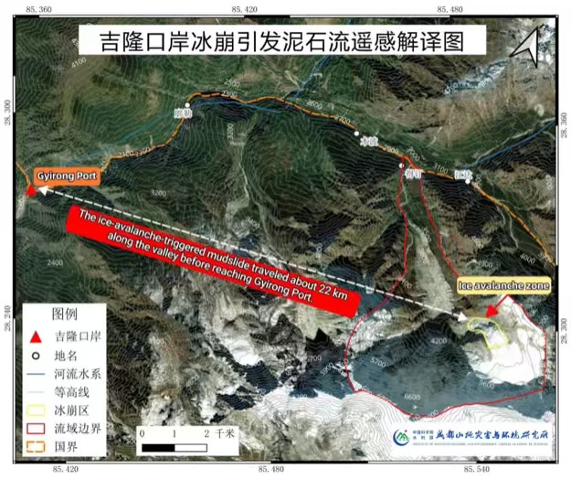
Guo Zhaocheng, director of the geological disaster investigation and monitoring center at the China Aero Geophysical Survey and Remote Sensing Center for Natural Resources, told CMG that the ice-avalanche debris flow traveled downstream along the Donglin Zangbo River before reaching Gyirong Port, where it struck buildings and infrastructure.
Guo said a high-altitude glacier in the upper reaches of the Cuojian River in Nepal collapsed at an elevation of around 5,140 meters. The collapse sent ice and rock debris rushing downhill, scouring and entraining loose deposits along the gully and forming a high-speed debris flow, he added.
The debris flow then entered the Guobaxiaqu River, a boundary river between China and Nepal, before joining the Donglin Zangbo River. It subsequently moved downstream along the river channel and evolved into a large-scale mudslide that struck Gyirong Port and continued toward downstream areas in Nepal.
The disaster is a cascading event: It starts with a high-altitude ice collapse, develops into a debris flow and finally grows into a massive mudslide.
Guo said the drastic elevation difference between the source area and Gyirong Port accounts for the extreme speed of the debris flow.
The source area in the upper Cuojian River sits at about 5,140 meters above sea level, while Gyirong Port is at an elevation of around 1,800 meters, Guo said, adding that the significant elevation difference creates an elevation drop of nearly 3,300 meters over a distance of about 20 kilometers.
Based on available time records, Guo said the glacier collapse began at around 10:52 a.m. on August 26, and video footage showed the mudslide reaching Gyirong Port at around 10:59 a.m.
That means the debris flow traveled nearly 20 kilometers in about seven minutes, with an estimated average speed of around 50 meters per second. Guo noted the speed was extraordinarily high, leaving people almost no time to react.
Beyond its extreme speed, the debris flow also produced a rare phenomenon after slamming into the main river channel at Gyirong: part of the flow traveled upstream against the river current. Analysis of the 3D imagery shows the mudslide flowed nearly 3 kilometers upstream in the Gyirong Zangbo River.