Online Reporter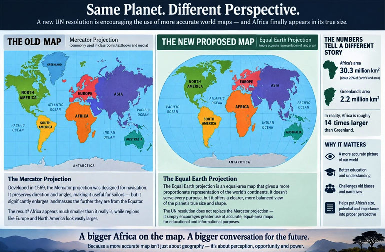
Lloyd Makonya
Correspondent
FOR centuries, generations of Africans have looked at the world through a map that made their continent appear smaller than it really is.
The famous Atlas would quickly come to mind. Now, the United Nations has taken an extraordinary step towards correcting that picture.
On September 4, the UN General Assembly adopted a resolution titled: “Correct the Map: Rebalancing Global Cartographic Representation and Promoting Equitable Representation of the World’s Regions, Particularly Africa”.
The resolution, sponsored by Togo and backed by the African group, received 164 votes in favour, one against and six abstentions.
It encourages countries, institutions and other users of maps to promote cartographic representations that more accurately reflect the relative size of the world’s continents.
At the heart of the initiative is the Equal Earth projection, an equal-area map designed to give a more proportionate representation of continental land masses. It is intended as an alternative to the familiar Mercator projection, which has dominated classrooms, textbooks and public consciousness for generations.
This is not really a story about cartography. It is a story about how human beings see the world and how the world has been taught to see Africa.
The Mercator projection was developed by Flemish cartographer, Gerardus Mercator in 1569 primarily as a navigational tool. Its great strength was preserving angles and directions, making it extremely useful to sailors.
Its weakness is that the further a landmass lies from the equator, the more its apparent size is exaggerated.
Africa, South America and other equatorial regions therefore appear significantly smaller than their actual areas, while northern regions appear much larger.
The distortion is striking.
Africa covers approximately 30,3 million square kilometres. Greenland covers about 2,2 million. In reality, Africa is roughly 14 times larger than Greenland. Yet on the familiar Mercator map, the two can appear deceptively similar in size. That mathematical distortion was never, by itself, evidence of an anti-African conspiracy. Mercator was solving a particular technical problem. The problem came later when a map designed for navigation became one of the world’s most powerful educational images.
A navigation tool became a picture of the world and pictures matter.
Children learn geography from maps long before they understand geopolitics, economics or history. A map can therefore become more than a technical representation.
It becomes part of our mental architecture, an image that silently tells us what is large, what is small, what is central and what appears peripheral.
For generations, Africa has often been visually compressed on the world’s most familiar maps while Europe and North America have appeared disproportionately large.
The UN initiative therefore deserves attention, not because changing a projection will magically transform Africa’s fortunes, but because it forces a difficult question: How much of what we believe about the world is shaped by the way information is presented to us?
That question becomes particularly important when applied to Africa. The continent is not merely large geographically. It is becoming increasingly consequential demographically, economically and strategically.
Africa’s population has grown from about 227 million in 1950 to more than 1,5 billion in 2024 and is projected to reach approximately 2,5 billion by 2050.
The continent is consequently going to account for an increasingly significant share of humanity’s future workforce, consumers and urban populations.
Africa is also central to some of the resources upon which the world’s technological and energy transition increasingly depends.
UN Trade and Development (UNCTAD) has highlighted the continent’s enormous reserves of minerals including cobalt, manganese, phosphate rock and platinum-group metals.
More recent UNCTAD work notes Africa’s substantial shares of global reserves of cobalt, manganese, graphite and other minerals critical to modern industry and renewable-energy technologies.
The paradox is therefore difficult to ignore. A continent that is geographically enormous, demographically young and strategically rich in natural resources has often been represented in global conversations as a collection of problems rather than a centre of opportunity. Perhaps that is why the map matters. Not because the old map caused Africa’s problems, but because it reminds us that representation and power are connected.
The African union has long articulated an ambition for a continent that is integrated, prosperous, self-reliant and influential in global affairs through Agenda 2063. Its priorities include economic transformation, value addition to natural resources, continental integration, infrastructure development and a stronger African voice in global affairs. In that sense, “Correct the Map” can be understood as part of a broader African conversation about agency.
A larger-looking Africa does not automatically mean a more powerful Africa. Changing the projection cannot build a railway. It cannot create a factory. It cannot stop illicit financial flows. It cannot prevent the export of raw minerals without sufficient local value addition. It cannot create jobs for Africa’s rapidly growing youth population. It cannot solve conflicts, strengthen institutions or improve governance. A continent does not become powerful because it looks bigger on a classroom wall. It becomes powerful when its people, institutions and economies can convert geography, resources and human capital into sustainable prosperity.
The African union itself recognises this. Agenda 2063 explicitly seeks to move Africa beyond the role of raw-material supplier by promoting value addition, industrialisation, intra-African trade and stronger continental integration. The African Continental Free Trade Area is part of that broader effort to strengthen Africa’s bargaining position and deepen trade within the continent.
The new map should therefore not become another symbol that makes Africans feel good for a few days before returning to business as usual. It should become a conversation starter. If the map can be corrected, perhaps some of the assumptions surrounding Africa can also be challenged. Why should African countries continue exporting raw materials and importing expensive finished products made from those same resources? Why should a continent with more than a billion people continue to approach its markets primarily as 54 separate national economies rather than as a potential continental marketplace? Why should Africa’s vast youth population be discussed mainly as a demographic challenge rather than as an enormous reservoir of talent, entrepreneurship and innovation?
Why should Africa’s mineral wealth be viewed principally through the lens of extraction rather than industrialisation? Why should African voices sometimes carry less weight in global institutions despite the continent’s growing demographic and strategic importance? These questions are far more consequential than the shape of a map.
Perhaps the most important question is not whether the world will now see Africa as bigger. It is whether Africans will begin to think bigger about Africa. The continent does not need a map to tell it that it is large. Africans have always known the physical reality of their homeland. What Africa needs is the political confidence, economic integration and institutional capacity to translate that scale into influence.
The map can help change perception and perception must eventually become policy. Policy must become investment. Investment must become production. Production must create jobs and prosperity. Prosperity must give ordinary Africans a greater stake in the continent’s future. That is tahe journey from symbolism to substance.
The UN vote is therefore worth celebrating but not because Africa has suddenly become larger. Africa was always this large. What has changed is that the world’s most important multilateral institution has acknowledged that the way we have traditionally represented the planet can distort our understanding of its proportions.