Online Reporter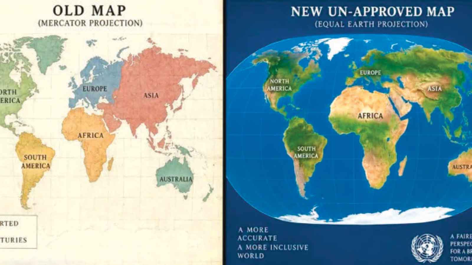
Ambassador Kwame Muzawazi
FOR centuries, Africans have looked at maps of the world and accepted, almost without question, a visual representation in which our continent appears smaller than it really is.
On September 4, 2026, the United Nations General Assembly took an important step towards correcting that distortion when it adopted a resolution championed by the Republic of Togo to promote a fairer representation of the world’s land masses, primarily through the “Equal Earth” projection.
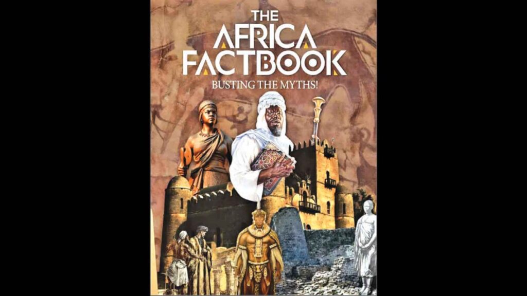
The Institute of African Knowledge (INSTAK) congratulates Togo for this historic initiative. We equally congratulate the United Nations General Assembly for embracing a position whose intellectual and evidentiary foundations that INSTAK has been advancing for years. Indeed, INSTAK raised this very question six years ago. In September 2020, INSTAK published the first edition of the Africa Factbook, and it carried an essay entitled “Cartography: Africa and the revisiting of the world map”.
Across pages 265 to 278, the Africa Factbook interrogated the distortions embedded in conventional world maps. Using statistical comparisons, the Africa Factbook demonstrated the extraordinary difference between Africa’s actual dimensions and how the continent is commonly portrayed.
The point was not merely cartographic. It was civilisational. As the Africa Factbook observes: “Maps are neither mirrors of nature nor neutral transmitters of universal truths.”
They are narratives. They tell stories about what is important, what is central and what is peripheral.
The statistics are startling. Africa covers approximately 30,37 million square kilometres. It is almost twice the size of Russia, three times the size of Canada and more than three times the size of the United States. It is almost four times the size of Australia and approximately 14 times larger than Greenland.
Yet a look at the conventional Mercator map gives the impression that Greenland is almost the size of Africa. Canada can appear larger. Russia appears enormous.
The Africa Factbook puts the matter directly: “Africa is bigger than Canada, the contiguous United States and China put together!”
The Mercator map was created in the 16th century, principally as a navigational tool and its use of local angles made it useful. The problem arose when a projection designed for navigation became, in effect, the world’s mental picture of geographical reality.
And the consequences are much larger than cartography. The Africa Factbook demonstrates that the Mercator projection “helped create the misleading Eurocentric world we see today, with great implications for global politics and economics, and negative consequences for regions like Africa”.
That is why the Togolese initiative deserves to be understood not as an argument about graphic design, but as part of Africa’s continuing effort to correct the narratives through which the world has understood – and misunderstood – our continent.
It should be noted that the UN resolution is not legally binding. It does not abolish Mercator. Mercator retains legitimate technical uses, particularly in navigation. What the resolution does, however, is encourage governments, educational institutions, publishers, international organisations and digital platforms to move towards representations that better preserve the relative areas of the world’s regions. That is a significant first step.
And sometimes history begins with first steps that appear deceptively small. Togo has already indicated that it intends to change its school geography materials, helping translate the international resolution into national practice. The African union had itself endorsed the Equal Earth projection earlier this year and urged Member States to revise their school curricula accordingly. The AU has now welcomed the UN decision and called for more accurate representations of Africa across educational systems, publishing and digital platforms.
Our schools should use maps that represent Africa according to its true proportions. Our governments, museums, universities, media houses, tourism institutions and public communication campaigns should do likewise. Our digital platforms and African technology companies should embrace more accurate representations of ourselves. This is not about making Africa look bigger. It is about making Africa look as it actually is.
There is a profound psychological dimension to this question. What we see repeatedly becomes part of what we believe.
A child who grows up seeing Africa visually diminished unconsciously internalises the idea of a continent that is small, peripheral and dependent. Conversely, seeing Africa represented in its proper proportions can become part of a broader process of restoring confidence and self-worth.
The Africa Factbook makes this connection explicitly, contending that Africans must challenge distorted historical narratives because doing so helps “boost the self-confidence of the people of Africa” and contributes to unlocking the continent’s economic potential. This matters in the real world.
Self-perception influences ambition. Ambition influences behaviour. Behaviour defines the future.
A people who understand the geographical scale of their continent, the size of its markets, the abundance of its resources and the strategic importance of its location are better positioned to negotiate with confidence. Africa is not a marginal geographical appendage. It is a continent of immense territorial scale, enormous natural resources, a young and growing population and extraordinary strategic importance. Maps cannot, by themselves, transform economies or alter international power relations. But representations shape perceptions, and perceptions influence the frameworks within which power is exercised.
The Africa Factbook, therefore, makes an even more fundamental observation: “Maps do not just represent our perceptions of the world; they also create them.” That sentence deserves to be placed in every African classroom – next to a proper graphic representation of the world map. We must resist the temptation to regard this issue as trivial. The question is not whether a particular line on a map is curved or straight.
The question is who has historically had the authority to define how Africa is seen.
The Africa Factbook urges Africans to employ maps for what they are: “psychological tools to project cultural, political, and historical values of their creators.” Africa must become a producer of knowledge, images, maps and narratives about itself — not merely a consumer of representations produced elsewhere. This is why INSTAK welcomes the Togolese initiative with particular satisfaction. Six years ago, when the first Africa Factbook was published, the issue was already clear: Africa needed to revisit the map, because the map was helping to shape how Africa was imagined. Today, the United Nations has placed that question firmly on the international agenda. The journey, however, has only begun.
Even if it takes decades, even if it takes centuries, truth has a peculiar quality: it will always emerge.
Africa’s true size has not changed because somebody drew it smaller. Our geography did not shrink because a projection distorted it. Our potential did not diminish because somebody else produced the map.
Ambassador Kwame Muzawazi is the Chief Executive Officer of the Institute of African Knowledge (INSTAK), the Harare-based Pan-African think tank that published the Book of African Records and the Africa Factbook, and is building the Museum of African Liberation as part of its Liberation City Project.