Sifelani Tsiko-Fact Check Editor
PROSPECTS are high for La Niña conditions to develop in the 2025-2026 rainfall season, according to a latest update by the 31st Southern African Regional Climate Outlook (SARCOF-31). Regional forecasters who met recently in Lusaka, Zambia, say there’s a greater chance that La Niña will develop this season, bringing wetter conditions.
La Niña is defined by cooler-than-average sea surface temperatures along the equator in the central and eastern Pacific region. Experts say these ocean waters can influence atmospheric activity — bringing increased chances of wetter conditions in Zimbabwe and other countries in southern Africa in the 2025/26 cropping season.
La Nina events arise from cooler sea surface temperatures in the Pacific, while warmer sea surface temperatures result in an opposite weather phenomenon called El Nino, which often results in low rainfall and searing heatwaves in Zimbabwe and neighbouring countries.
What does a statement by SARCOF (31) project say?
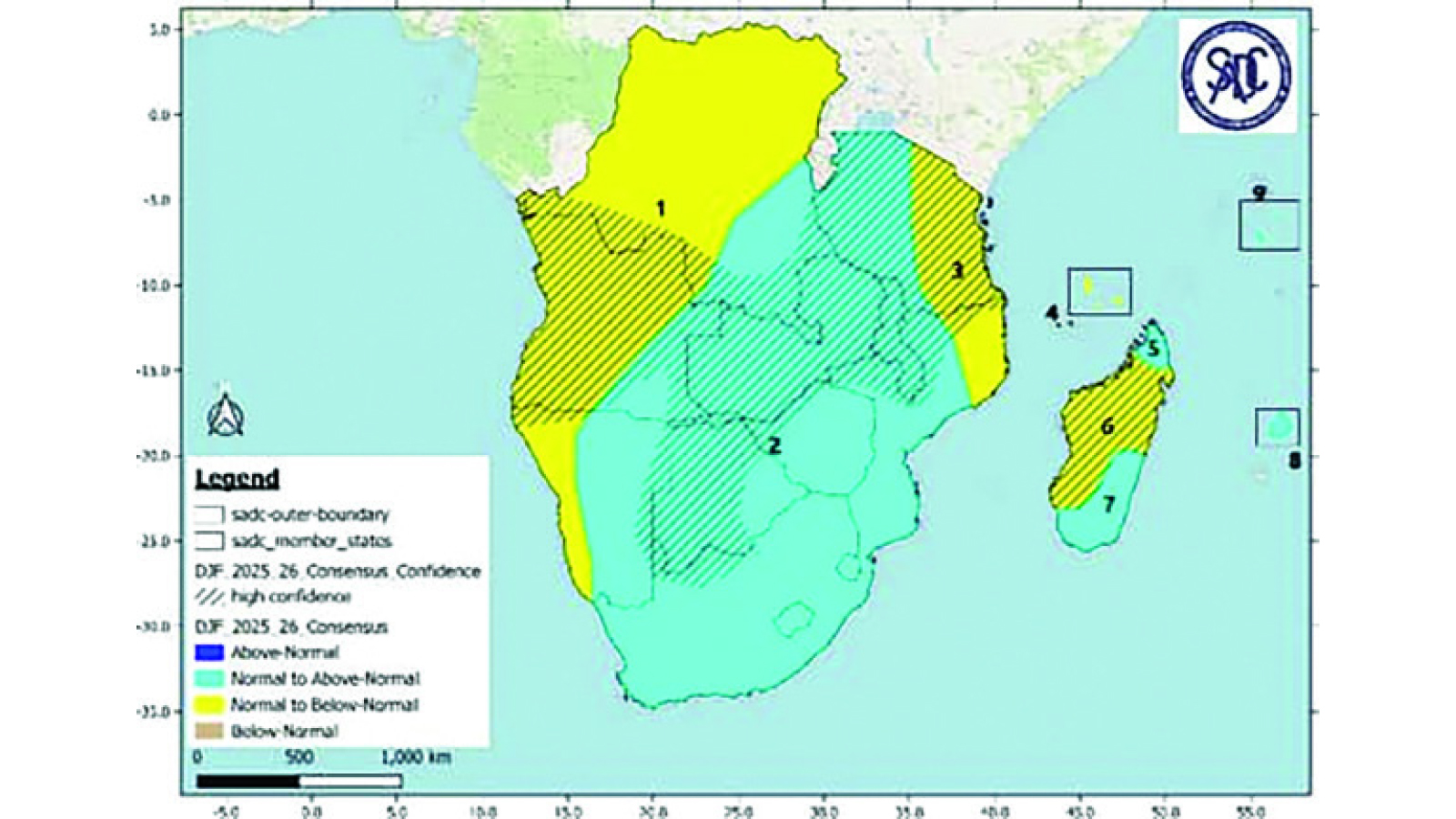
“Bulk of the SADC region is likely to receive normal to above-normal rainfall for most of the period of October to December (OND) 2025 except the western fringes of Namibia where below-normal rainfall is expected. The remainder of the region is likely to receive normal to below normal rainfall during this period of the 2025/26 season including the island states of Comoros, Madagascar, Mauritius and Seychelles.
The period of January to March (JFM) 2026 period is expected to have normal to above normal rainfall for most of the region except for northern parts of the region (Angola, DRC and Tanzania) where normal to below normal rainfall is expected. Above normal rainfall is expected in the southwestern parts of the region while the bulk of Madagascar, Mauritius and Seychelles are expected to receive normal to above rainfall with Comoros receiving normal to below normal rainfall during the JFM 2026 period.”
What climate experts said on temperature?
“Temperature outlook for the entire 2025/26 rainfall season indicates that temperatures are expected to be mostly above long-term averages over the whole of the SADC, except for central parts of the region.”
What does a La Nina mean for Zimbabwe and southern Africa?
La Ninas are normally associated with wet conditions for Zimbabwe and the entire southern Africa sub-continent, but a local weather expert cautioned that they sometimes don’t result in widespread rain. Climate experts further say that La Nina events are also associated with heightened risk of cyclones as well as cool daytime temperatures. Meteorological Services Department (MSD) forecasters are expected to give a detailed forecast for Zimbabwe soon. This could spell out how the La Niña will develop in the October-November-December (OND) period and play a role in rainfall distribution across much of the country. So far, a SARCOF 31 map (October 2025 to January 2026 Rainfall Outlook) shows that the greater half of Zimbabwe — east, central and southern parts are likely to receive above normal rains while the northernmost arc — north and north western regions will get normal to above normal rains. The La Niña weather event typically brings good rains in Zimbabwe and most other southern African countries. It has provided relief for the entire sub-continent after a devastating drought ravaged this region in the 2023-2024 cropping season. The region is getting a second consecutive wetter season this time.
Why do the La Nina and El Nino weather phenomenon attract regional and global attention?
The formation of a La Nina event and its opposite, El Nino, often attract global attention because of its impact on agriculture in southern Africa and other parts of the world. There is often high anticipation that a La Nina event will bring huge relief to the southern Africa region which is prone to droughts. In southern Africa, La Niña events are generally associated with cooler, wetter conditions, but experts say this is not guaranteed and can vary by the duration of the event. These events are part of the El Niño-Southern Oscillation (ENSO) cycle and can impact regional rainfall and temperature, influencing agriculture and food security. Zimbabwe and most other SADC countries recorded the lowest rainfall in decades in the 2023-2024 cropping season resulting in increased food insecurity and water shortages across the region. The El Nino weather pattern has affected agricultural production and other key sectors like tourism, industry and energy production.
What are the risks that come with La Nina conditions?
While the expected wet conditions are beneficial, they can also lead to flooding, especially in low-lying areas. There are also other potential risks that come with a good season. Countries in the region are likely to battle increased outbreaks of locusts, armoured crickets and the fall armyworm and experts say countries in the region should plan and intensify surveillance of pests to minimise damage to crops. Locusts can cause serious damage to sorghum, maize and pastures, as they and other pests breed abundantly in wetter conditions with rapid vegetation growth. Excessive rains also come with numerous public health risks that include cholera, malaria and others. These must be planned for in addition to pests and diseases that affect our livestock.
Flooding, cyclones and leaching is also likely in this coming season and experts said countries should encourage areas which were vulnerable to put in proper drainage measures, do contouring for ridging to protect crops and assist with drainage and canals. Strategies should be devised and implemented for managing leaching, which is the loss of valuable fertiliser applications. Excessively wet conditions due to incessant rains can negatively affect crop growth due to leaching of nutrients, especially nitrogen, from the soil.
What strategies are needed for farmers to cope with wetter spells?
Heavy rains could increase chances of waterborne diseases such as malaria and cholera, increased livestock diseases and other public health problems. Another important measure for farmers to adopt, will be to construct infiltration pits that originally work to capture rain water in a prolonged dry rainy season or erratic rainy season to prolong moisture availability within a cropping area. These structures will assist in drawing excessive water away and out of the cropping area, thus reducing the amount of time this water stands in the field, therefore reducing leaching rate. This can significantly work towards redirecting this excessive rain water run-off into existing underground water aquifers. More cyclones tend to be seen in La Nina years, but the worst to hit Zimbabwe in half a century, Cyclone Idai at the end of the 2018-19 season occurred in an El Nino year. Climate experts warned that member states should not be complacent as the region is likely to experience an average or above-average number of tropical cyclones this season.
Why disaster risk planning is critical for Zimbabwe and SADC
Tropical Cyclone Idai, the worst in more than 50 years, brought heavy rainfall and strong winds to Malawi, Mozambique and Zimbabwe between March 5 and 19 2019, causing severe flooding which led to loss of lives, destruction of infrastructure, disruption of livelihoods and destruction of crops. Climate experts say countries must conduct public education and awareness campaigns and set up areas for temporary shelter in case of flooding and cyclones. Given the risks that come with cyclones and flooding, it is important to promote the people-centred approach to early warning systems to help our communities understand threats and how they can avoid them. Disasters are largely caused by natural hazards, but they also stem simply from people being ignorant, and in the wrong place without adequate protection. Information must extend to communities so as to facilitate their adoption of protective actions. Zimbabwe and most countries in the region need to utilise telecommunication mobile networks and the media to disseminate information coming from our early warning systems to prevent damage and save lives.
Integrating telecommunication systems and disaster risk action
Telecommunications can play an important role in using ICTs for disaster risk reduction and management, through the design of national emergency telecommunication plans, setting up early warning and monitoring systems and providing emergency telecommunications equipment when disasters strike. All this can help warn people about floods and other disasters ahead of time. It is also important for the regional countries to mobilise resources for disaster risk response on time. Response action plans and units often lack adequate resources and funds to carry out their work. Most governments tend to wait for disaster to strike first before any resources are allocated. Setting budgets aside is key to help disaster response teams to respond quickly and reduce both the severity of the emergency and the number of people affected.