Chronicle Reporter
A team of Zimbabwean, South African, British and Danish academics has established that Great Zimbabwe ran an integrated, climate-smart water harvesting, storage and management system that ensured security of supply through dry seasons.
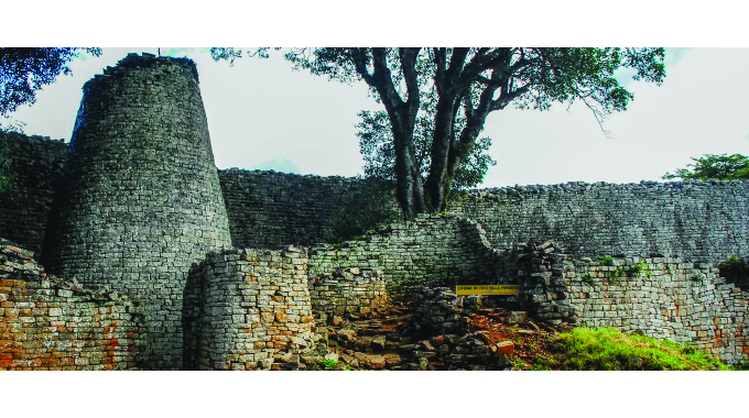
The city, founded in ninth Century but abandoned in the 17th, had a population of between 10 000 and 18 000. At its peak around the 11th Century it oversaw most parts of present-day Zimbabwe and Mozambique.
Using remote sensing and geoarchaeology, the eight academics, four of whom are Zimbabweans, found out that residents of the ancient settlement were served by a network of 40m by 10m and up to two metres deep pits where water collected during wet seasons and were relied upon during periods of dryness such as winter and droughts.
“These pits were part of a landscape-scale water management system that exploited catchment hydrology and groundwater by means of artificial ‘dhaka’ reservoirs, wells, and springs to secure water for subsistence, farming, ritual and ceremony services,” they note, urging water-starved urban centres in the country and elsewhere on the continent to draw lessons from Great Zimbabwe.
The paper, “Climate-smart harvesting and storing of water: The legacy of dhaka pits at Great Zimbabwe” by Zimbabwean professors Innocent Pikirayi and Shadreck Chirikure, Mr Munyaradzi Elton Sagiya and Ms Tendai Musindo; Dr David Stott, a Briton, Dr Bongumenzi Nxumalo, a South African and Professor Søren M. Kristiansen, a Dane, was published last month in the Journal Anthropocene.
They conducted fieldwork between 2014 and 2019 to survey, identify and record landscape sequences and water sources in and around southern Africa’s greatest medieval city.
The research located several, circular ‘dhaka’ pits at the foot of the Hill Complex, to the west and east of the Great Enclosure and on the slopes of Mutero Hill. The depressions tend to straddle streams, with some of them blockaded by earthen dams.
Comparing the features with the channel network reconstructed from the digital terrain model, the study notes, it was evident that the pits are located in positions that maximised collection and retention of surface run-off.
“Though fragmented,” says the document, “the growing body of environmental and archaeological records when integrated with historical and ethnographic information, do paint a new, convincing portrait of Great Zimbabwe: a landscape where human settlement, land and water were intimately linked for a long time and to some extent, continue to do so. Springs and rainwater fed an urban population of ruling elites, religious leaders, craftsmen, and merchants. Water storage facilities were strategically placed to maximise supply and demand.”
Noting the water supply challenges in a number of cities locally and on the continent including Harare, the academics indicate that Great Zimbabwe’s legacy offers an opportunity to appreciate the role of biophysical integration, community cohesion and innovation to support settlement over time.