Liberty Dube
Tourism Correspondent
SITUATED in Nyahokwe Village in Nyanga is a historic tourism monument, Nyahokwe Ruins, that is, not only iconic in the country, but globally.
The site is about 7km away from another majestic monument, Ziwa Monument, which is on the United Nations Educational, Scientific and Cultural Organisation (UNESCO) World Heritage tentative list.
Ziwa is one of the two sites on the tentative list, with the other one being the Naletale Cluster of Dzimbabwe, located about 90km south of Gweru.
For a site to be considered for the UNESCO World Heritage Sites, State parties are encouraged to submit their tentative lists, properties which they consider to be cultural and or natural heritage of outstanding universal value, and therefore suitable for inscription on the World Heritage List.
Every visitor to Nyahokwa Monument has to pass through Ziwa Monument as there are no resident custodians at the site.
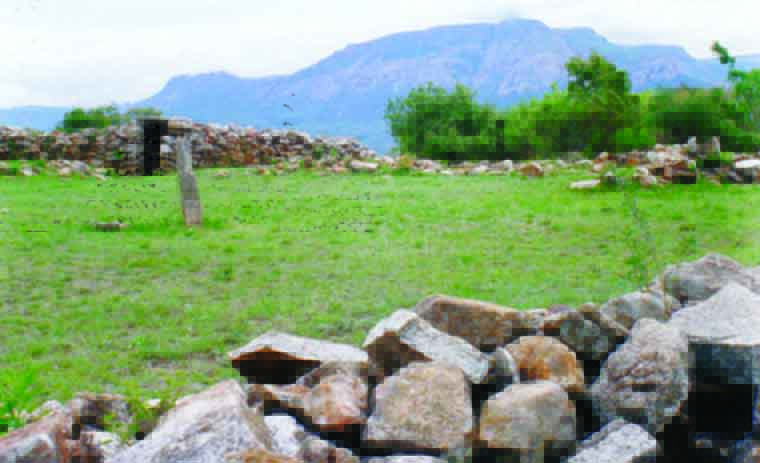
The remains these communities left behind such as stone-walled village complexes, stone-lined pit structures and the vast area of hill-side terracing make this area one of the most magnificent of its kind in Zimbabwe. Nyahokwe Village is a granite built site which is National Monument Number 99.
It is located on the top of Nyahokwe Mountain and it has similar characteristics of other monuments in Nyanga.
According to Len Mullin in his book Historic Trees of Zimbabwe, he stated that Zimbabwe’s rarest native tree, the only Juniper Tree (Juniperusprocera), is located at the Nyahokwe Monument Site.
The strength of the Juniper Tree is seen in its capacity to survive in harsh and bare climates, growing out of rocks and surviving in areas with very little water.
Evidence from excavations carried out on the site show there has been occupation from hunter-gatherer periods of the Early Stone Age about 50 000 years ago in the form of crude tools that were made by striking flakes of stone off a rock.
The stone flakes, or flake tools, that were struck off the cores, were used for cutting and skinning animals, or to work plant materials.
The crude tools of the Early Stone Age were succeeded by smaller, more varied and finely made stone weapons of the Middle and Late Stone Age.
The hunter-gatherers were succeeded by a more settled agricultural people who brought with them domesticated animals, crops and used pottery, iron tools and weapons.
The Ziwa culture (200 to 800AD) was a pre-cattle rearing farming community who raised sheep and goats in settlements.
Although the culture lasted for at least 600 years, visible remains are very few as the people lived in flimsy huts and rarely built rudimentary terraces in stone.
Nyahokwe and Ziwa Monuments were visited by Dr Heinrich Schlichter in 1897 and Dr Carl Peters in 1900.
Dr Peters claimed to have discovered the sites and deserted gold mines of the Kingdom of Mutapa, which he identified as the legendary ancient lands of Ophir and wrote an account of his travels in a book, The Eldorado of the Ancients, in 1902.
This area contains numerous sites relating to the Ziwa people, the earliest Iron Age inhabitants of Manicaland whose culture lasted for at least 600 years from 200AD, with examples of the Ziwa pottery and iron work exhibited in the Ziwa Site Museum.
A path leads a few metres west to the reconstruction of an iron smelting furnace.
Behind the furnace is a simple pit structure with an unusually small pit.
Another path leads the way up to Nyahokwe mountain. After a short distance, one path goes east to a further simple enclosure and typical pit structure.
The main path leads on a steep climb of about a kilometre, past terracing and a further pit structure to the Nyahokwe Village site crouched under the cliff face of the very summit of the mountain.
The village site itself is enclosed by a rough wall and entered through the usual lintelled entrance, which gives onto an inner passage.
The sloping ground within contains numerous stone slab foundations of what were probably grain stores and also one strange circular cairn, almost a small “conical tower”, whose real function is unknown.
Just east of the path as it approaches the village, and about 100m below it, the level plateau of bare granite is scarred by a great number of grinding grooves in the native dolerite rock, often six or more purposely grouped within reach of one person seated at their centre.
These were probably used for grinding grain, rather than the preparation of ores.
The great level circle, 18m in diameter, with upright stones set round its perimeter formed, from local African parallels, a “dare” or meeting place of the village elders.
Leading off the dare to the northeast is a large pit structure whose typical features of tunnel, pit, platform and particularly hut circles are very clear.
National Museums and Monuments of Zimbabwe Manicaland Assistant curator of archaeology, Mr Shingirai Sakarombe said: “It is a place with rough stone walls and with ample space where elders would meet to discuss societal issues. It is a dare.
“There is a standing stone on the middle which is believed that people, particularly elders of that time, would conduct rituals and other rites. On its side there is a pit that animals would stay or hide, known as pit structures.
“There is also an enclosure which has symbols of heart foundations as well as a stone with a picture of a six-year-old child which was exhumed. There are some rock paintings, a duala and lower grinding stones where women would grind their agricultural products.
“Evidence available show that there were agricultural activities that would take place. Terraces were there to prevent erosion. Nyahokwe is a mountain that is used by contemporary sites where they take it as burial site for traditional leaders. It is sacred and magnificent.”