Tawanda Musarurwa-Checkpoint Desk
FOR the second year in a row, Zimbabwe’s rainy season is expected to be affected by a La Niña event (which typically brings more rains to regions like south-eastern Africa).
But when Harare’s skies open and storms sweep across the city, not everyone is hit equally.
The latest Harare Master Plan (2025-2045) flood risk data, layered with census and housing figures, reveals that the impact of climate change also exposes inequality.
The map of risk
A flood map of the city contained in the master plan shows patches of red, high and very high flood risk, concentrated along rivers and wetlands.
The Mukuvisi, Manyame and Marimba rivers cut through suburbs that are already struggling with overcrowding and poor infrastructure. Southern and eastern Harare, including the suburbs of Budiriro, Epworth, Dzivaresekwa, Kuwadzana and Mabvuku, for example, are hotspots.
By contrast, northern suburbs like Borrowdale and Mount Pleasant, where housing is larger and better serviced, sit mostly outside the danger zones.
According to the Harare master plan, the central business district (CBD) area is the most vulnerable to flood risk, but so too are the southern suburbs.
“The city is highly susceptible to flooding risk due to its geographical location on the watershed coupled with rapid urbanisation, poor drainage infrastructure and climate variability.
“The flood risk is particularly high in the Central Business District (CBD) and southern suburbs, where inadequate stormwater drainage systems lead to frequent flooding,” reads part of the master plan.
“Encroachment of urban development on wetlands, which naturally absorb excess water, has exacerbated surface runoff, increasing the severity of flooding.
“Informal settlements, often built in flood-prone areas, are especially vulnerable.”
It is largely a reflection of the colonial state.
Harare, which was built on the water gathering area of Lake Chivero, was designed with a north-south divide.
The northern suburbs, originally reserved for Europeans, were laid out on higher ground with planned drainage. Southern suburbs like Highfield and Mbare were sited on flood-prone land near wetlands.
Who lives where
The 2022 Population and Housing Census counted around 206 365 people in Epworth alone.
Household incomes in Epworth are less than half those in northern suburbs.
More than 70 percent of homes are informal, brick walls and corrugated iron roofs, few drains and little to no flood defences.
In Glen View and Budiriro old property values average between just US$10 000 and US$30 000.
According to global real estate consultancy Knight Frank’s Zimbabwe Market update (H2, 2024), contemporary high-density properties in Harare are priced between US$60 000 and US$80 000, medium-density at US$120 000 and US$250 000 and the low-density ones around US$500 000.
The difference in housing prices mirrors the difference in exposure. Satellite imagery confirms this.
Comparative analysis of Epworth, Borrowdale
A comparative analysis of Google Earth maps by this publication shows that Epworth faces a high flood risk because it sits on low-lying terrain with poor drainage, widespread informal housing and encroachment into wetlands.
The lack of stormwater infrastructure and fragile socio-economic conditions make residents especially vulnerable, with floods often leading to displacement and health crises.
Borrowdale, by contrast, lies on higher ground with planned housing, better drainage and stronger municipal services, meaning flooding is usually localised along streams like Borrowdale Brooke.
The flood risk disparity between Epworth and Borrowdale is just a sample of the wider problem. According to the 2022 Population and Housing Census, an estimated 296 365 residents live in just the two high/very-high flood risk areas of Epworth and Budiriro.
The Budiriro 5B and Kuwadzana Paddocks floods
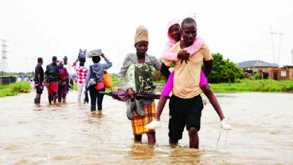
The floods that took place in December 2023, which affected residents that had illegally settled in the Budiriro 5B Extension and Kuwadzana Paddocks area, highlighted the reality of the dangers of flooding in areas without proper drainage infrastructure.
At least 59 households were affected. A report by the Zimbabwe Gender Commission on the floods highlighted the burden on vulnerable communities.
“The crisis exacerbated pre-existing inequalities by intensifying the burden of care and domestic labour for women and girls.
High density suburbs are largely affected by flooding.
“With limited resources and cramped conditions, women at the evacuation centres face the immense challenge of ensuring their children’s well-being, including their nutritional needs and hygiene, under constant resource constraints and rationing,” read the ZGC assessment report.
In an interview with this publication at the time, Budiriro 5B residents’ representative Mr Pasipanodya Nyamayaro said they were tired of short-term solutions.
“Moving out of our houses every year as if we do not pay rates to council is unbearable. They set up evacuation camps every rainy season since 2017, but we now need long-term solutions to our problems, because we are likely going to experience the same challenge next year.”
Why flood risk falls on the poor
Urban planners say low-income suburbs face high flood risk due to poor planning and wetland encroachment.
“The risk exposure of lower income suburbs such as Budiriro, Mabvuku, Epworth can be explained from a planning perspective, as well as from a geographical reality of some of them being in low-lying areas.
“In most of the areas, settlements have encroached deep into wetlands and flood zones of rivers. Water follows gradient and terrain formation, so use of such spaces is not negotiable,” said town planning expert Dr Percy Toriro.
“Whilst there is a huge gap between supply and demand, providing housing to poor people in risky spaces where construction is environmentally unsustainable, technically complex and beyond their financial capacity is not recommended.”
The Report of Justice Uchena Commission on Sale of Urban Stateland, which was presented to President Mnangagwa in 2019, showed underlying problems driving the unsustainable land use, including: new residential estates lacking essential services such as roads, water and sewerage; occupation of settlements without proper infrastructure; developments undertaken without approved engineering designs; inadequate policies and corruption.
It is not just an issue of geography. Wealthier families can pay for insurance, raise walls or even move, while poorer households cannot. Once floods strike, property values fall further. And in flood-prone suburbs, women, children, and people with disabilities suffer most due to fragile housing, unsafe water, and long-term insecurity.
Looking at it broadly, living in high flood risk areas perpetuates a poverty cycle because flooding directly damages property, leading to a decline in home values.
A 2022 World Bank study titled; “Putting a Price on Safety: A Hedonic Price Approach to Flood Risk in African Cities” found that flood risk is associated with lower rental prices in several African cities.
Funding gaps
The new Harare Master Plan calls for relocating people from flood zones, restoring wetlands and upgrading drainage.
But, residents are less optimistic that this can be done expediently.
Said Harare Residents Trust director Mr Precious Shumba: “Land barons and other corrupt enablers of corruption know that the poor are vulnerable and exploit it to the maximum.
“While flooding does not discriminate along socioeconomic lines, the poor lack the financial resources and access to critical information to assist them in making better decisions.”
The Justice Uchena Commission estimated that at least US$2,5 billion was required for total infrastructural needs of urban state land in and around urban areas countrywide.
But, Harare City Council’s budgets, for example, fall short of making significant improvements in emerging flood-prone communities
In 2024, of Harare’s approved budget of US$578 million, the bulk of this money (US$442,5 million) went towards recurrent expenditure.
This means last year the city spent less than 23 percent of its budget on critical infrastructure such as drainage and waste management.
Without significant investment, experts warn, the inequitable flood risk pattern could deepen.
The problem of flooding risks also speaks to the country’s commitments under the Sustainable Development Goals (SDGs).
Flood vulnerability in poor suburbs directly undermines progress on SDG 6 (clean water and sanitation), SDG 11 (sustainable cities and communities), SDG 13 (climate action) and risks widening inequality (SDG 10).
The bigger picture
Harare’s inequality under climate stress is not unique.
“Though felt globally, climate change has a distinctive urban impact, as 64 percent of the urban population has a high level of exposure to disasters,” says the United Nations Human Settlements Programme (UN-Habitat) in its 2024 World Cities Report.
“The urban poor, particularly residents of informal settlements, are disproportionately exposed to extreme weather events on account of their location, poor quality of construction and limited savings.”
In its sixth assessment report, the Intergovernmental Panel on Climate Change (IPCC) warned that Southern Africa could see more intense rainfall events.
Cities without adequate planning will face rising costs in terms of in money, health and lives. For Harare, the data is unambiguous.
Poverty and flood risk overlap. As informal housing fills floodplains, health crises such as the Budiriro floods in 2023 follow; but wealthier suburbs are largely protected.
Climate change is often seen as universal, but the flood map shows otherwise.
The poorest communities live where the water rises fastest, where houses are weakest, and where recovery costs the most.
Harare and other cities’ futures depend on whether they can close this gap by investing in drainage, protecting wetlands and building affordable, safe housing.
The Government has since drafted the Urban State Land Management Policy, which is expected to end the proliferation of informal settlements lacking basic services.
Such efforts need to be accelerated, or the poor may end up paying the highest price of a changing climate.